Denise
Moderator
As the western media has all sight fused on Hurricane Irene nearing New England, There is another Hurricane or typhoon as the are called in the Pacific is considerably more conserning as a category 4...Hurricane Irene is only a category 1.
More info on this is here:
Taiwan issues warning as strong typhoon approaches
Sat Aug 27, 2011 4:12pm GMT
TAIPEI Aug 27 (Reuters) - Taiwan has issued a warning to residents of its southern and eastern regions as powerful typhoon Nanmadol approaches after hitting the northern Philippines.
Nanmadol caused flooding and landslides and knocked out power in northern areas of the Philippines, but was weakening as it approached Taiwan.
Taiwan's central weather bureau said the typhoon, with winds of 45 metres per second, is slow moving. The bureau warned of landslides and flooding in mountain areas and of strong winds.
A maritime warning is already in place and ferry services and flights to some outlying islands have been cancelled. Southeast China's coastal province of Fujian has ordered local ships to seek harbour due to the approaching storm, the Xinhua news agency reported.
Storm tracking service Tropical Storm Risk currently classifies Nanmadol as Category 4, one below the most serious, but sees it weakening to Category 2 in 72 hours. See www.tropicalstormrisk.com/.
The storm arrives almost exactly two years after Typhoon Morakot cut a wide path of destruction over southern Taiwan, leaving some 700 people dead or missing and causing some $3 billion of damage.
The government of President Ma Ying-jeou was heavily criticised for a slow response to the disaster. Ma faces presidential elections in January. (Reporting by Jonathan Standing)
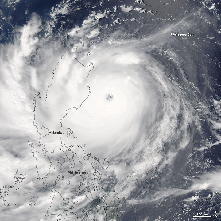
Nanmadol formed as a tropical depression over the western Pacific Ocean on August 22, 2011. It strengthened to a tropical storm a day later, and by August 26, it was a super typhoon.
The Moderate Resolution Imaging Spectroradiometer (MODIS) on NASA’s Aqua satellite captured this natural-color image of Super Typhoon Nanmadol at 12:50 p.m. Manila time on August 26, 2011. The eye of the storm appears east of the northern Philippines, and Nanmadol spans hundreds of kilometers.
As of 11:00 p.m. Manila time on August 26, 2011, the U.S. Navy’s Joint Typhoon Warning Center (JTWC) reported that Nanmadol had maximum sustained winds of 135 knots (250 kilometers, or 155 miles, per hour) and gusts up to 165 knots (305 kilometers, or 190 miles, per hour). The storm was located roughly 585 nautical miles (1,085 kilometers, or 675 miles) south-southwest of Kadena Air Base, Japan. The storm was forecast to continue traveling toward the north-northwest before turning toward the northeast.
On August 26, 2011, the Associated Press reported that at least one person in the Philippines was missing and several towns in the northern Philippines were flooded by heavy rains from the slow-moving storm. http://earthobservatory.nasa.gov/Nat...=51886&src=nha
More info on this is here:
Taiwan issues warning as strong typhoon approaches
Sat Aug 27, 2011 4:12pm GMT
TAIPEI Aug 27 (Reuters) - Taiwan has issued a warning to residents of its southern and eastern regions as powerful typhoon Nanmadol approaches after hitting the northern Philippines.
Nanmadol caused flooding and landslides and knocked out power in northern areas of the Philippines, but was weakening as it approached Taiwan.
Taiwan's central weather bureau said the typhoon, with winds of 45 metres per second, is slow moving. The bureau warned of landslides and flooding in mountain areas and of strong winds.
A maritime warning is already in place and ferry services and flights to some outlying islands have been cancelled. Southeast China's coastal province of Fujian has ordered local ships to seek harbour due to the approaching storm, the Xinhua news agency reported.
Storm tracking service Tropical Storm Risk currently classifies Nanmadol as Category 4, one below the most serious, but sees it weakening to Category 2 in 72 hours. See www.tropicalstormrisk.com/.
The storm arrives almost exactly two years after Typhoon Morakot cut a wide path of destruction over southern Taiwan, leaving some 700 people dead or missing and causing some $3 billion of damage.
The government of President Ma Ying-jeou was heavily criticised for a slow response to the disaster. Ma faces presidential elections in January. (Reporting by Jonathan Standing)
Nanmadol formed as a tropical depression over the western Pacific Ocean on August 22, 2011. It strengthened to a tropical storm a day later, and by August 26, it was a super typhoon.
The Moderate Resolution Imaging Spectroradiometer (MODIS) on NASA’s Aqua satellite captured this natural-color image of Super Typhoon Nanmadol at 12:50 p.m. Manila time on August 26, 2011. The eye of the storm appears east of the northern Philippines, and Nanmadol spans hundreds of kilometers.
As of 11:00 p.m. Manila time on August 26, 2011, the U.S. Navy’s Joint Typhoon Warning Center (JTWC) reported that Nanmadol had maximum sustained winds of 135 knots (250 kilometers, or 155 miles, per hour) and gusts up to 165 knots (305 kilometers, or 190 miles, per hour). The storm was located roughly 585 nautical miles (1,085 kilometers, or 675 miles) south-southwest of Kadena Air Base, Japan. The storm was forecast to continue traveling toward the north-northwest before turning toward the northeast.
On August 26, 2011, the Associated Press reported that at least one person in the Philippines was missing and several towns in the northern Philippines were flooded by heavy rains from the slow-moving storm. http://earthobservatory.nasa.gov/Nat...=51886&src=nha